
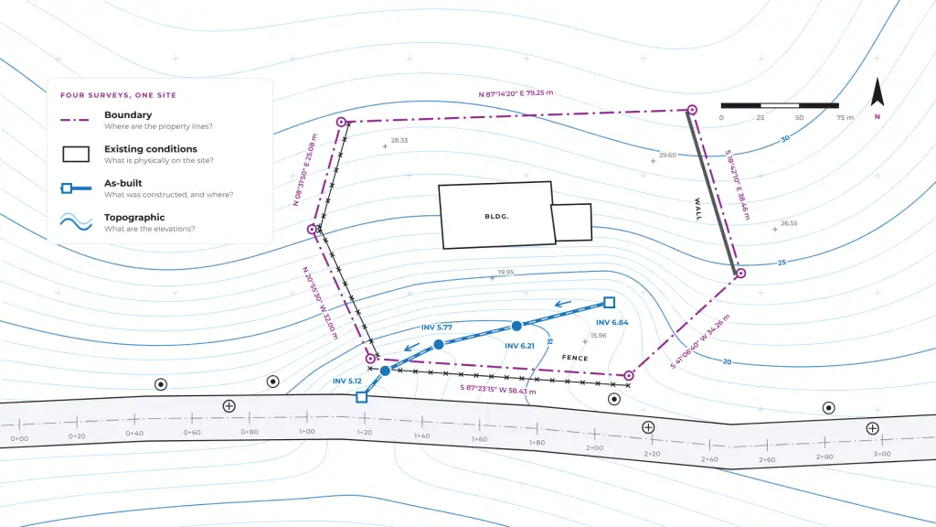

Mensura, As-Built, Existing Conditions, and Topographic SurveysUnderstanding What You Are Really Asking For
A practical guide for engineering, environmental, architectural, and project teams to define the survey service their project actually needs.
In Puerto Rico, the word mensura is often used to describe almost any survey-related plan.
A project team may ask for a “mensura for design,” a “mensura of the existing building,” or a “mensura showing what is there.” But in many cases, a mensura — understood professionally as a boundary survey — is not actually what the project needs.
The appropriate service may instead be an existing conditions survey, topographic survey, as-built survey, or a combination of several survey services.
The distinction is more than terminology. Each service answers a different question, requires different fieldwork and research, carries different professional responsibilities, and produces information for different project decisions.
For engineering, environmental, and architectural teams, understanding these differences can help define better scopes, compare proposals more accurately, and avoid discovering later that critical information was never included in the survey.
01Start with the decision, not the name of the survey
Before requesting a “mensura,” start with a different question:
What decisions will we make using this survey information?
For example, does the project need to:
- understand existing site conditions for design?
- locate buildings, pavement, utilities, fences, walls, drainage features, or other improvements?
- obtain elevations for grading or drainage design?
- determine legal property boundaries?
- evaluate easements, encroachments, or access?
- document improvements after construction?
- support permitting or agency review?
- design improvements to a road, utility, drainage system, site, or structure?
These are different needs, and they do not necessarily require the same survey. A plan showing existing physical features is not automatically a boundary survey. A boundary survey does not automatically include the detailed elevations needed for engineering design. An as-built does not necessarily determine ownership limits. And a topographic survey can support design without resolving title or boundary questions.
Define the purpose first. Then define the survey.
02What is a mensura or boundary survey?
In Puerto Rico, mensura is commonly used as a general term for survey work. Professionally, however, it is generally associated with a boundary survey: work involving the determination, verification, or documentation of property limits.
A boundary survey is not simply a drawing showing what exists on a property. It can require analysis of:
Where are the property lines, and what evidence supports that determination?
That makes boundary surveying both a technical and legal exercise:
- The fence observed in the field may not be on the property line.
- Cadastral information may be incomplete or inconsistent with title information.
- An old survey may conflict with a deed.
- Physical occupation may not correspond with the recorded description.
Resolving those issues requires research, reconciliation of evidence, and professional judgment — not simply measurement.
Why does this matter?
A boundary determination can affect property rights, adjoining owners, easements, access, encroachments, acquisitions, rights-of-way, development limits, and future transactions. That professional responsibility is fundamentally different from documenting the physical features needed by a design team.
03What is an existing conditions survey?
An existing conditions survey documents what is physically present at a site for purposes such as planning, design, permitting, or coordination. Depending on the project, it may include:
- Buildings and structures
- Pavement, curbs, and sidewalks
- Walls, fences, and gates
- Poles, manholes, and drainage structures
- Visible utilities
- Access points
- Roadway features
- Vegetation limits
- Other surface features relevant to the project
What is physically present on the site?
What it does not necessarily determine:
- Who owns the land
- Where the legal property line is located
- Whether a fence agrees with the deed
- What recorded easements affect the property
If those questions matter to the project, additional boundary and title-related work may be required.
04What is an as-built survey?
An as-built survey generally documents improvements after they have been constructed or installed. It may include:
What was constructed, and where is it located?
Depending on the project requirements, the survey may also document elevations, compare constructed improvements with design plans, or provide information needed for record drawings and project closeout.
As-built surveys are commonly used for:
An important distinction remains:
An as-built survey does not automatically constitute a boundary survey.
Unless boundary research and analysis are specifically included in the scope, legal property limits should not be assumed to have been determined simply because they appear in an as-built deliverable.
05What is a topographic survey?
A topographic survey documents existing site conditions together with elevation information. It becomes particularly important when design decisions depend on understanding the vertical relationships across a site. Depending on the scope, it may include:
What exists on the site, and what are the elevations?
This information is commonly required for civil engineering, drainage, roadway and utility design, flood-control projects, grading, ADA accessibility, coastal or water-related work, construction planning, and earthwork analysis.
If the design depends on contours, slopes, drainage relationships, invert elevations, or finished grades, a general request for a “mensura” may not adequately communicate what the project requires.
06Four surveys, four different questions
| Survey type | Primary question | Typical purpose |
|---|---|---|
| Boundary Survey / Mensura | Where are the property lines, and what evidence supports them? | Property limits, title-related matters, encroachments, acquisition, easements |
| Existing Conditions Survey | What physical features exist on the site? | Planning, architectural design, coordination, site documentation |
| As-Built Survey | What was constructed, and where? | Construction verification, record drawings, closeout |
| Topographic Survey | What exists, and what are the elevations? | Engineering design, drainage, grading, roads, utilities |
A project may require one of these services — or several of them together.
07Existing conditions and topographic surveys can overlap
These two services are particularly easy to confuse because both document what exists. The distinction is often the project’s need for vertical information.
For example:
May primarily need the locations of buildings, parking, access, walls, fences, and other improvements.
May need those same features, but also ground elevations, contours, pavement slopes, drainage structures, invert elevations, channels, and outfalls.
The second assignment requires a much greater understanding of the site’s vertical relationships. That difference affects field time, survey control, processing, and quality review.
08The same feature can mean different things in different surveys
Consider a fence.
The fence may simply be documented because the design team needs to know where it physically exists.
That same fence may become evidence that must be considered when evaluating occupation and its relationship to the property’s legal boundaries.
The physical feature is the same. The professional question being answered is different.
This is why the intended use of the survey should be established before fieldwork begins.
09Four practical examples
10Why getting the terminology right affects cost and schedule
The distinction between these services directly affects the effort required:
Utilities, drainage systems, dense vegetation, water bodies, restricted access, or agency-specific requirements may add further complexity.
When the requested service is unclear, two problems can occur:
- The proposal excludes work the client expected, requiring additional services later; or
- the proposal includes work the project did not actually require, increasing cost unnecessarily.
A clearly defined purpose allows the surveyor to develop a more appropriate scope, fee, schedule, and deliverable — and allows the client to compare proposals based on equivalent requirements.
11Before requesting a survey proposal
Before sending an RFP or asking a surveyor for a fee, the project team should consider:
These questions are more useful than simply asking for a “mensura.”
12A simple way to remember the difference
Where are the property lines, and what evidence supports that determination?
What physical features exist on the site today?
What was constructed, and where is it located?
What exists on the site, and what are the elevations?
Sometimes a project needs only one. Frequently, infrastructure and complex design projects require a combination.
13The surveyor’s role begins before the fieldwork
A professional surveyor should help the project team clarify these requirements before mobilizing a field crew. When someone asks for a “mensura,” useful follow-up questions include:
- 1What is the survey going to be used for?
- 2Will the information support design?
- 3Do you need legal property limits?
- 4Do you need elevations?
- 5Are easements or title information important?
- 6Do you need existing improvements documented?
- 7Are you documenting completed construction?
- 8Will an agency review the survey?
- 9Will the information eventually support permitting, acquisition, construction, or project closeout?
These questions are not intended to complicate a project. They help make sure the survey being performed is the survey the project actually needs.
14Final thought
Not every survey plan is a mensura, and not every project requesting a mensura actually needs a boundary survey.
For engineering, environmental, and architectural teams, understanding the difference between boundary surveys, existing conditions surveys, as-built surveys, and topographic surveys helps establish better scopes and obtain information that is appropriate for the decisions ahead.
The most useful question is therefore not: “What kind of survey do we usually request?”
What does our project need to know?
Once that question is clear, the appropriate survey scope becomes much easier to define.
Not sure which survey your project needs?
Tell us what decisions the survey will support, and we’ll help you define the right scope before a field crew is mobilized.
Talk to RLTR about your scope